


Étang de la Bonde

phugues
User
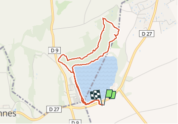

Length
4.6 km

Max alt
390 m

Uphill gradient
75 m
Km-Effort
5.6 km

Min alt
328 m

Downhill gradient
75 m
Boucle
Yes
Creation date :
2022-04-12 08:02:54.254
Updated on :
2022-04-12 09:35:07.493
1h31
Difficulty : Easy

FREE GPS app for hiking
 SityTrail
IGN / Geographical institutes
SityTrail Plus
The world is yours!
About
Trail Walking of 4.6 km to be discovered at Provence-Alpes-Côte d'Azur, Vaucluse, La Motte-d'Aigues. This trail is proposed by phugues.
Positioning
Country:
France
Region :
Provence-Alpes-Côte d'Azur
Department/Province :
Vaucluse
Municipality :
La Motte-d'Aigues
Location:
Unknown
Start:(Dec)
Start:(UTM)
701890 ; 4848063 (31T) N.
Comments